-
Call: +(91) 84696-08000
-
Email: info@dronelab.in
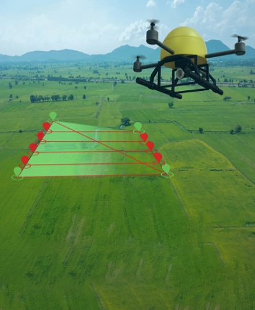
Surveying & Mapping
Where We Can Use!
Real time & accurate insight into security, Remote Area Inspection, Risk Assessment and perimeter control.
- Land Survey
- Mining Survey
- Road Survey
- Railway Survey
- Solid Waste Survey
- City Survey
- Canal Survey
- River Survey
- Property Survey
Orthomosaic
Orthomosaic imaging offers significant advantages over traditional methods like Google Maps and presents an opportunity for more precise measurements. Utilizing small drones equipped with high-resolution cameras, multiple photos can be captured from different angles to cover larger areas. By merging these images into a cohesive orthomosaic, a comprehensive and accurate representation of the site can be obtained. This technology allows professionals to measure and analyze the site's features and dimensions with increased precision, all from the convenience of their office desk. The resulting orthomosaic provides valuable insights for various industries, such as construction, surveying, and urban planning, enhancing efficiency and decision-making processes.
- Format: TIFF, JPEG

3D point cloud to cad
A 3D point cloud is a collection of cartesian coordinates (X, Y, and Z) that accurately depict the geometry of a given scene. Comprised of millions or even billions of points, these digital representations faithfully mimic the real world. Each coordinate corresponds to the precise size and position of objects within the scene. As a result, we can perform measurements, inspections, and inventories with a level of accuracy equivalent to being physically present in the field. Point clouds enable us to analyze and interact with three-dimensional data, facilitating tasks such as modeling, simulation, visualization, and analysis across a range of industries and applications.
- Format: LAS, LAZ

DTM (Digital Terrain Model)
A Digital Terrain Model (DTM), also known as a topographic model, represents the natural, unobstructed surface of the Earth and can be manipulated using computer software. DTM data files contain elevation information of the terrain in a digital format, typically organized into a rectangular grid. By digitally removing vegetation, buildings, and other cultural features, the DTM focuses solely on the underlying terrain. This provides a clear representation of the Earth's surface, allowing for precise analysis, measurements, and modeling. DTMs find applications in various fields, including cartography, geology, hydrology, urban planning, and environmental assessment, aiding in decision-making and understanding the bare Earth's topography.
- Format: TIFF
.gif)
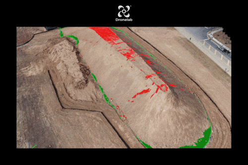
Flood Water Visualisation
A Digital Terrain Model (DTM) is a computer-manipulated topographic model representing the natural surface of the Earth without any obstructions. DTM data files consist of elevation data of the terrain presented in a digital format, typically organized in a rectangular grid structure. Through digital processing, vegetation, buildings, and other cultural features are digitally removed, leaving behind only the underlying terrain. This allows for a focused analysis of the Earth's surface, enabling accurate measurements, simulations, and modeling. DTMs are widely used in fields such as cartography, geology, hydrology, urban planning, and environmental assessment, providing valuable insights into the topography of the bare Earth and supporting informed decision-making processes.
- Format: TIFF

Contour
Contour lines are created by connecting points that share the same elevation, forming continuous lines on a terrain map. They provide valuable insights into the characteristics of the surface, aiding in the analysis of water flow patterns, land steepness, and overall terrain nature. When contour lines are generated using drone data, they tend to be significantly clearer and free from noise. Drones equipped with high-resolution cameras capture detailed and precise imagery, allowing for accurate elevation data extraction. This results in contour lines that offer enhanced clarity, enabling better understanding and interpretation of the terrain's features. The utilization of drone-generated contour lines improves mapping and analysis processes in various fields, including land surveying, engineering, and environmental planning.
- Format: DXF, SHP

Stockpile Calculation
One of the primary applications of drones at worksites is measuring stockpiles, and their ability to capture irregular shapes makes them a valuable tool for volumetric analysis. Unlike traditional methods, surveying stockpiles with drones captures all the intricacies of the shape and renders them in a survey. This allows computer software to accurately calculate the volume of the true shape, rather than relying on rough approximations. Companies can leverage drones to calculate stockpile volumes on a weekly or monthly basis, enabling efficient inventory management, cost estimation, and project planning. The regular monitoring of stockpile measurements using drones enhances accuracy, reduces manual labor, and improves decision-making processes in industries such as construction, mining, and logistics.
- Format: TIFF, JPEG
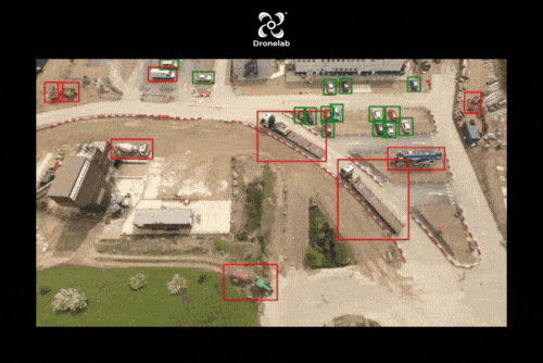
Object Marking
Object marking has the potential to revolutionize various drone applications, including topographical surveys, earthworks, and stockpile calculations. By utilizing object marking techniques, drones can accurately identify and mark important features such as road markings, drain markings, manhole markings, and unwanted objects. This capability enhances the precision and efficiency of survey work by providing clear and precise annotations on the captured data. Object marking enables streamlined workflows, facilitates data analysis, and improves the accuracy of measurements and calculations. With the ability to mark and identify specific objects of interest, drones equipped with object-marking capabilities offer significant advantages in industries such as civil engineering, construction, infrastructure management, and land surveying.
- Format: DXF, TIFF
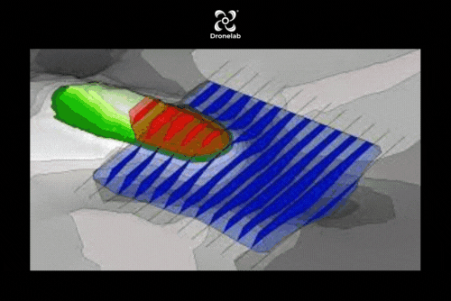
Cut/fill analysis
Cut/Fill analysis, a method used to evaluate the disparity in area and volume between two surfaces, is greatly enhanced by drone data. Drones enable precise identification of areas and volumes that require modification, either through material removal or addition, by capturing detailed surface information. The accuracy of Cut/Fill analysis using drone data surpasses traditional methods, as drones can detect even minor irregularities that were previously overlooked. The rough approximations made by conventional techniques are rendered obsolete by the level of precision achieved through drone-based analysis. This advancement enables more efficient and accurate earthworks, construction planning, and land management, leading to improved decision-making and cost estimation in various industries.
- Format: DXF, SHP
Thermal Orthomosaic
Drones equipped with infrared cameras have gained popularity due to their ability to capture thermal images of buildings, offering numerous practical applications. Building inspections benefit greatly from this technology, as drones can provide detailed imagery of both exteriors and interiors, aiding in the identification of issues like moisture intrusion, insulation gaps, and structural damage. Energy efficiency assessments are enhanced through thermal imaging, as drones can pinpoint areas of heat loss, enabling targeted improvements for reduced energy consumption and cost savings. Roof inspections are made more efficient as drones can detect damage and leaks, while infrared cameras detect trapped moisture, allowing for timely maintenance and prevention of larger issues.
- Format:
