-
Call: +(91) 84696-08000
-
Email: info@dronelab.in
Inspection
Where We Can Use!
Real time & accurate insight into security, Remote Area Inspection, Risk Assessment and perimeter control.
- Ship Construction
- Powerline inspection
- Solar inspection
- Wind Turbine inspection
- Bridge Inspection
- Heritage Inspection
- Aircraft Inspection
- Port Inspection
Photography
The use of drone photography for inspecting infrastructural utilities and assets is revolutionizing the inspection sector. Drones equipped with high-resolution cameras are transforming the way various issues are identified and addressed. They excel in detecting cracked insulators, corrosion, vegetation encroachment, damaged poles (split, leaning, etc.), open fuses, conductor issues, and overheating equipment. By capturing detailed photographs from unique perspectives, drones provide inspectors with valuable visual data for accurate analysis. This technology enhances inspection efficiency, reduces costs, improves safety, and enables proactive maintenance strategies. The application of drone photography in infrastructure inspections is propelling the sector to new heights, ensuring the reliability and longevity of vital assets.
- Format:
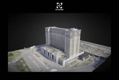
3D Model
The use of drone 3D models for inspecting industrial utilities and assets is revolutionizing the inspection sector in unprecedented ways. It offers significant advantages over traditional methods, including cost-effectiveness, time savings, and enhanced safety measures. By creating detailed 3D models of assets, drones enable inspectors to remotely analyze and assess the condition of equipment, structures, and infrastructure. Regular weekly or monthly inspections using drones can lead to increased asset lifespan and improved performance. The ability to identify potential issues early on allows for timely maintenance and repairs, preventing costly downtime. The transformative impact of drone inspection is reshaping the industry, ensuring efficient asset management and optimal operational performance.
- Format:
Thermal Hotspot Mapping
Thermal hotspot mapping by drones has revolutionized the inspection industry, providing a significant boon to asset inspections. Before the incorporation of drones, thermal mapping of assets was a labor-intensive task with minimal safety measures for surveyors. However, drones equipped with thermal imaging cameras have transformed this process. Thermal imaging plays a vital role in asset inspection by detecting stressed regions, cracks, overheating spots, and damaged components. The ability to capture detailed thermal data from a safe distance enhances the safety of inspectors and increases efficiency. Drones enable quick and accurate identification of potential issues, allowing for timely maintenance and ensuring the integrity of assets. The integration of thermal hotspot mapping with drones has elevated the standards of asset inspections, making them safer, more efficient, and highly effective.
- Format:

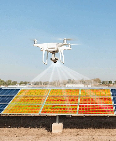
Solar farm Inspection
Solar inspection using drones has revolutionized the way solar installations are inspected and maintained. Drones equipped with high-resolution cameras and thermal imaging sensors can capture detailed aerial images of solar panels, enabling quick and accurate analysis of their condition. The thermal imaging capability allows for the detection of hotspots, which indicate potential issues such as faulty cells or electrical problems. By identifying these problems early on, maintenance teams can take prompt action to maximize energy production and prevent further damage. The use of drones significantly reduces inspection time, lowers costs, and improves overall efficiency in the solar industry, ensuring optimal performance of solar installations.
- Format:
.gif)
Road Crack Detection
Detecting 1200 road cracks in less than 2 hours can be achieved by leveraging the power of drones and advanced digital image processing techniques. Drones equipped with high-resolution cameras can quickly capture aerial images of road surfaces, covering large areas efficiently. These images can then be processed using advanced algorithms that analyze the visual data to detect and classify road cracks accurately. By automating this process, drones can rapidly scan the road network, overcoming the limitations of traditional visual inspections. This approach saves time, enhances inspection efficiency, and enables proactive maintenance strategies for road infrastructure, ensuring safer and well-maintained roadways.
- Format:
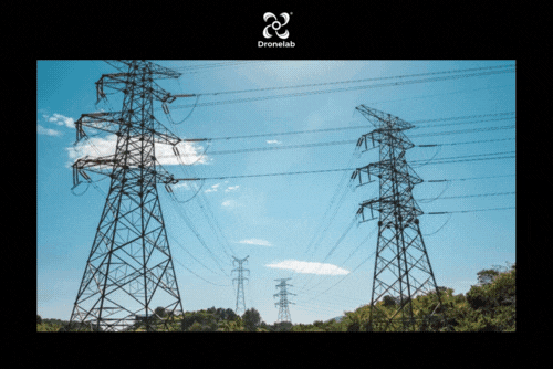
Powerline Inspection
Powerline inspection using drones offers several benefits in ensuring the reliability and efficiency of the electrical infrastructure. Equipped with high-resolution cameras, drones can capture detailed images of power lines, enabling the identification of erosions, cracks, and other signs of wear and tear. Thermal cameras, on the other hand, allow the detection of unseen electrical malfunctions by capturing heat signatures. Drones also play a crucial role in identifying vegetation overgrowth that could potentially interfere with powerlines, helping to prevent outages and ensure uninterrupted power supply. By providing quick and accurate visual assessments, drones enhance the structural preservation, defect detection, and vegetation management processes in powerline inspections, resulting in improved reliability and reduced downtime.
- Format:
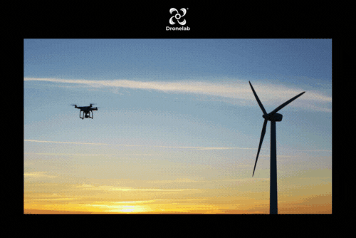
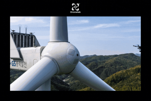
Wind Turbine Inspection
Drone-based inspection of wind turbines offers numerous advantages, enhancing their lifespan and overall performance. Unlike expensive and time-consuming traditional inspections that rely on 3D models, drones provide a cost-effective and efficient solution. Equipped with AI algorithms, drones can accurately locate faults and anomalies on wind turbines with higher precision. By capturing high-resolution images and videos, drones enable detailed analysis of turbine components, including blades, towers, and nacelles. This proactive approach to inspection allows for early detection of potential issues, facilitating timely maintenance and minimizing downtime. With the combination of drones and AI, wind turbine inspections become more effective, cost-efficient, and contribute to the extended longevity of these vital renewable energy assets.
- Format:
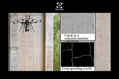
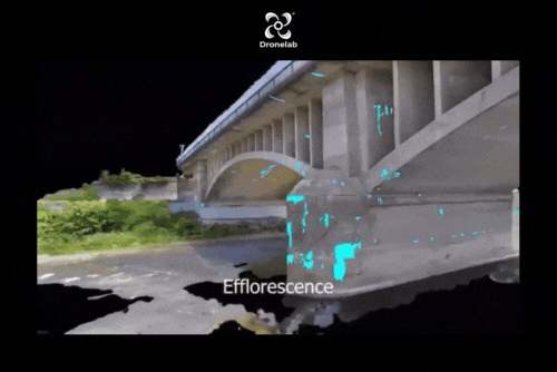
Bridge Inspection
Drones offer a cost-effective solution for the rapid identification of bridge damages, performance issues, and capacity deterioration. Their ease of deployment and affordability enable engineers to conduct regular inspections and monitoring of bridges, leading to improved maintenance practices and enhanced safety measures. By utilizing drones, engineers can efficiently assess the condition of bridge structures, identify any potential weaknesses or damages, and promptly address them. This proactive approach helps extend the service life of bridges, reducing the risk of unexpected failures and ensuring the continued safe operation of these critical infrastructure assets. Drones play a crucial role in optimizing bridge maintenance and enhancing overall bridge safety.
- Format:
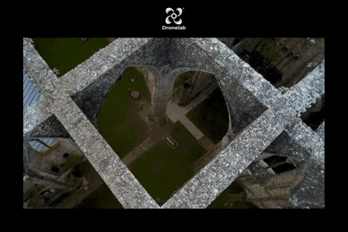
Heritage Inspection
Intel drone technology is playing a vital role in the preservation of cultural landmarks. By capturing thousands of high-resolution images, drones enable the documentation of areas that are challenging or unsafe for humans to access. These images are then utilized to create a comprehensive 3D digital replica of the structure, allowing for detailed assessments and analysis. This technology helps in identifying potential risks, detecting structural weaknesses, and planning necessary restoration or conservation efforts. By providing a non-invasive and efficient means of capturing and analyzing data, Intel drones contribute to the preservation and safeguarding of cultural landmarks for future generations to appreciate and study.
- Format: