-
Call: +(91) 84696-08000
-
Email: info@dronelab.in
Construction
Where We Can Use!
Real time & accurate insight into security, Remote Area Inspection, Risk Assessment and perimeter control.
- Building Construction
- Railway Construction
- Earthwork Tracking
- As-Built Comparisons
- Tasks & Schedules
- Quality Assurance
- Sub-Contractors Tracking
- Budget Control
- Warehouse construction
- Ship Construction
- Metro Construction
- Ropeway Construction
- Road Construction
- Bridge Construction
360° indoor shoot
A 360-degree indoor shoot at a site using a drone offers a comprehensive and immersive visual representation of the interior space. Equipped with specialized cameras, drones can capture high-resolution images or videos from all angles, providing a complete view of the surroundings. This technology allows for the creation of virtual tours, architectural visualizations, or documentation of construction progress. With the ability to navigate through tight spaces and capture aerial perspectives indoors, drones offer a unique and efficient solution for showcasing interior designs, evaluating spatial layouts, and presenting immersive experiences. The 360-degree indoor shoot with a drone facilitates enhanced communication, remote inspections, and decision-making processes in fields such as real estate, construction, and interior design.
- Format:
.gif)
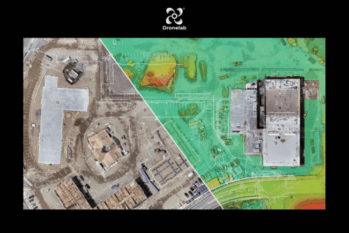
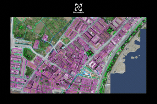
2D Orthophoto
Drones equipped with survey-grade precision and accuracy capabilities offer sub-inch or sub-3cm level measurements. These drones can georeference data to user-defined coordinate systems, ensuring alignment with specific spatial references. The captured images are rectified and true-to-scale, eliminating object tilting and providing accurate representations of the site. Real-time visualization of construction sites is made possible, allowing for online viewing or downloading of data in different formats. This technology revolutionizes surveying and mapping processes, providing efficient data collection, analysis, and visualization. With drones, industries such as construction, engineering, and land surveying benefit from enhanced precision, streamlined workflows, and improved decision-making based on reliable and up-to-date spatial information.
- Format:
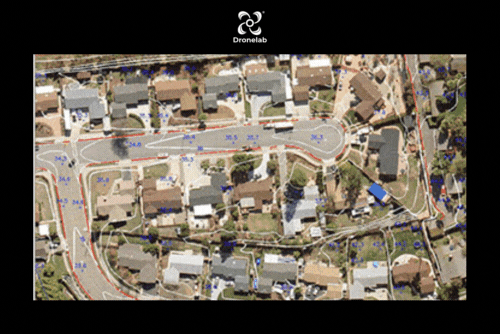
3D with measurement tool
Drones equipped with survey-grade precision and accuracy capabilities offer sub-inch or sub-3cm level measurements. These drones can georeference data to user-defined coordinate systems, ensuring alignment with specific spatial references. The captured images are rectified and true-to-scale, eliminating object tilting and providing accurate representations of the site. Real-time visualization of construction sites is made possible, allowing for online viewing or downloading of data in different formats. This technology revolutionizes surveying and mapping processes, providing efficient data collection, analysis, and visualization. With drones, industries such as construction, engineering, and land surveying benefit from enhanced precision, streamlined workflows, and improved decision-making based on reliable and up-to-date spatial information.
- Format:
Cad Overlay
Cad Overlay with drones involves overlaying Computer-Aided Design (CAD) data onto captured drone imagery or point clouds. By using specialized software, CAD drawings and models can be precisely aligned with the real-world data captured by drones. This overlay enables accurate spatial referencing and visualization of design plans in their intended context. It facilitates the identification of discrepancies, clash detection, and visual verification of construction progress on the site. CAD Overlay with drones enhances communication, coordination, and decision-making in construction and infrastructure projects by providing a clear and accurate representation of design intent and enabling effective collaboration among stakeholders. It streamlines workflows, minimizes errors, and improves overall project efficiency.
- Format:
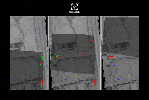
Change detection
Change detection with drones involves comparing aerial data captured at different time points to identify and analyze changes that have occurred in a specific area or site. By capturing high-resolution imagery or point clouds with drones, changes in vegetation, structures, land use, or other features can be detected. Advanced image processing and analysis techniques enable accurate identification and quantification of these changes. This information is valuable for various applications such as land management, environmental monitoring, urban planning, and infrastructure inspections. Change detection with drones provides a cost-effective and efficient method to track and assess changes over time, facilitating informed decision-making and proactive management of resources and assets.
- Format:
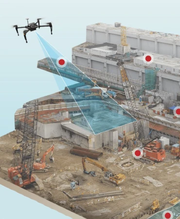
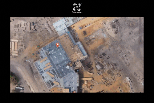
Day/ week Project Progress Monitoring
Using drones for day/week project progress monitoring offers a valuable tool for construction and infrastructure projects. Drones equipped with high-resolution cameras capture aerial imagery, providing an up-to-date visual record of the project site. These images can be compared to previous data to assess the progress made over specific time intervals. By overlaying project plans or 3D models onto the drone imagery, stakeholders can visually track the construction timeline, identify potential delays or issues, and ensure adherence to project milestones. Drone-based progress monitoring improves communication, enhances transparency, and enables timely decision-making, ultimately leading to more efficient project management and successful project outcomes.
- Format:
Project Progress dashboard
A project progress dashboard with drones integrates data captured by drones into a centralized platform, providing real-time insights and visualizations of construction or infrastructure projects. The dashboard combines aerial imagery, 3D models, and other data sources to create an interactive and comprehensive view of the project. Stakeholders can monitor key metrics, track progress, and identify areas of concern through intuitive visual representations. Drone data, including orthomosaics, point clouds, and thermal images, can be analyzed and integrated into the dashboard, enabling informed decision-making, efficient resource allocation, and proactive risk management. The project progress dashboard with drones enhances collaboration, improves project oversight, and facilitates timely interventions for successful project execution.
- Format: